Creating a Local OSM Extract
Your own little OpenStreetMap database
Overview
- Introduction
- OSM Data
- Import Scenarios
- Keeping it Up to Date
- Using it
- Questions
OpenStreetMap Data
What is OSM?
“The Wikipedia of Maps”
OSM is a dataset, which is…
- global
- open
- used to map nearly anything
- one of my favorite things
Is anyone actually using it?
- Amazon Logistics
- Tesla Smart Summon feature
- Esri (basemaps, feature services)
- Pokemon Go
- Red Cross
- Kendall County!
OpenStreetMap Data:
It’s weird!
The OSM dataset has:
- NO layers
- NO schema
- NO polygons

The Structure
OSM data is made up of:
- Nodes
- Ways (ordered series of nodes)
- Relations (collection of other elements)
Let’s look at an example!
Looking at it: Nodes
{
  "elements": [
    {
      "type": "node",
      "id": 6650982353,
      "lat": 41.6620246,
      "lon": -88.5328721,
      "tags": {
        "direction": "forward",
        "highway": "stop"
      }
    },
    {
      "type": "node",
      "id": 235170089,
      "lat": 41.6630576,
      "lon": -88.5327984,
      "tags": {
        "railway": "crossing",
        "crossing:bell": "yes"
      }
    },
    {
      "type": "node",
      "id": 235170094,
      "lat": 41.6637334,
      "lon": -88.5327199
    }
  ]
}Looking at it: Ways
{
  "elements": [
    {
      "type": "way",
      "id": 21814608,
      "nodes": [
        6650982353,
        235170089,
        235170094
      ],
      "tags": {
        "highway": "tertiary",
        "name": "Lew Street"
      }
    },
    {
      "type": "node",
      "id": 6650982353,
      "lat": 41.6620246,
      "lon": -88.5328721,
      "tags": {
        "direction": "forward",
        "highway": "stop"
      }
    },
    {
      "type": "node",
      "id": 235170089,
      "lat": 41.6630576,
      "lon": -88.5327984,
      "tags": {
        "railway": "crossing",
        "crossing:bell": "yes"
      }
    },
    {
      "type": "node",
      "id": 235170094,
      "lat": 41.6637334,
      "lon": -88.5327199
    }
  ]
}Looking at it: Areas
Looking at it: Areas?
Looking at it: Relations
{
  "elements": [
    {
      "type": "relation",
      "id": 10004268,
      "members": [
        {
          "type": "way",
          "ref": 21814608,
          "role": ""
        }
      ],
      "tags": {
        "name": "Plano City Road 1",
        "network": "US:IL:Plano",
        "type": "route",
        "route": "road"
      }
    },
    {
      "type": "way",
      "id": 21814608,
      "nodes": [
        6650982353,
        235170089,
        235170094,
        235170095,
        6650982353
      ],
      "tags": {
        "barrier": "wall"
      }
    }
  ]
}Looking at it: Relations
{
  "elements": [
    {
      "type": "relation",
      "id": 10004268,
      "members": [
        {
          "type": "way",
          "ref": 21814608,
          "role": "outer"
        },
        {
          "type": "way",
          "ref": 21814722,
          "role": "inner"
        },
        {
          "type": "way",
          "ref": 21815110,
          "role": "inner"
        },
        {
          "type": "way",
          "ref": 21814600,
          "role": "inner"
        }
      ],
      "tags": {
        "building": "yes"
      }
    }
  ]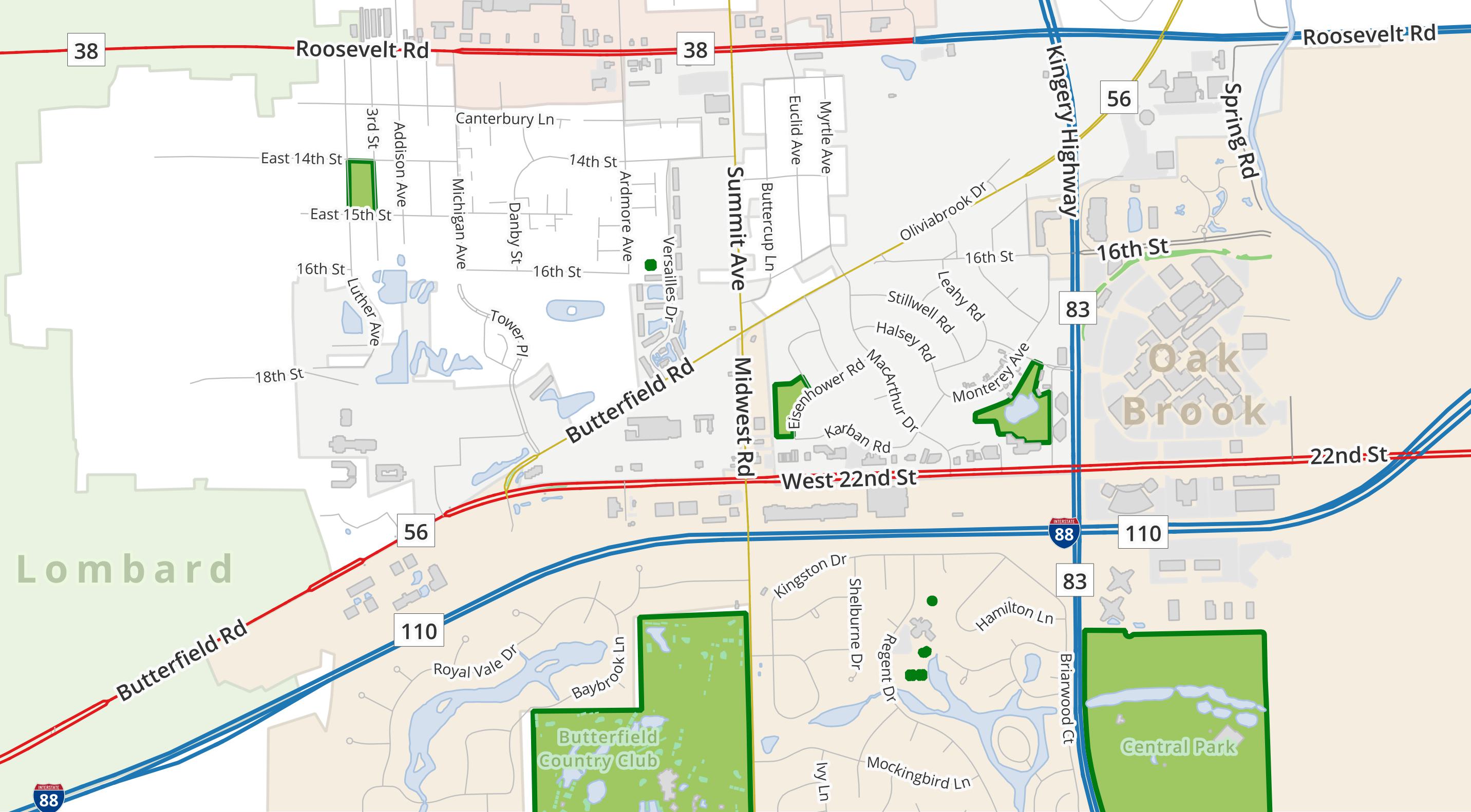
}So how does this…
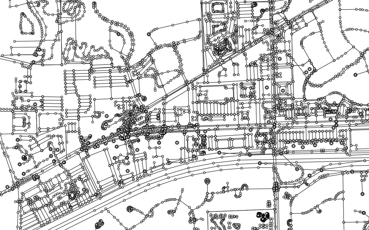
…turn into this:
Getting the Data
Sources
Prep the Data
Osmium
A “swiss army knife” for OSM data.
- Extracting geographic subset
- Getting metadata about objects
- Extract by attribute
- Generate / apply change files
- and more!
Audience
Participation!
Extracting with Osmium
Importing with imposm
Pros / Cons
- Easy to use and configure
- Built in tag “cleaning”
- Table generalization
- AOI filtering on import and update
- Relations are harder to work with
- No advanced geometry processing or configuration
- AOI does not apply to relations
- Development seems to have plateaued
Table Config
Mapping OSM data to tables is done using a YAML config file.
highways-mapping.yml
Importing: Single Table
Importing: Single Table
Importing: Multiple Tables
Importing: EVERYTHING
And prepping for future updates!
Everything?
Importing With osm2pgsql
Pros / Cons
- Well established, continued development
- Extremely configurable
- Allows geometry processing “mid-stream”
- Exports to many coordinate systems
- Decent default config
- Lots of examples
- Updating requires a replication URL, not easily limited to AOI
- Custom configuration can be harder to adjust / understand
- Built-in generalization is experimental
Importing: Defaults
Take the plunge!
The osm2pgsql maintainers strongly encourage using the flex output, especially if you’re just starting out using it. The default output does not always take advantage of new capabilities.
Flex Output
Mapping to tables is done with a Lua file.
pois.lua
local pois = osm2pgsql.define_table({
    name = 'pois',
    ids = { type = 'any', type_column = 'osm_type', id_column = 'osm_id' },
    columns = {
        { column = 'name' },
        { column = 'class', not_null = true },
        { column = 'subclass' },
        { column = 'tags', type = 'jsonb'},
        { column = 'geom', type = 'point', not_null = true },
  }
})

function process_poi(object, geom)
    local a = {
        name = object.tags.name,
        geom = geom,
        tags = object.tags
    }

    if object.tags.amenity then
        a.class = 'amenity'
        a.subclass = object.tags.amenity
    elseif object.tags.shop then
        a.class = 'shop'
        a.subclass = object.tags.shop
    else
        return
    end

    pois:insert(a)
end

function osm2pgsql.process_node(object)
    process_poi(object, object:as_point())
end

function osm2pgsql.process_way(object)
    if object.is_closed then
        process_poi(object, object:as_polygon():centroid())
    end
endImporting: POIs
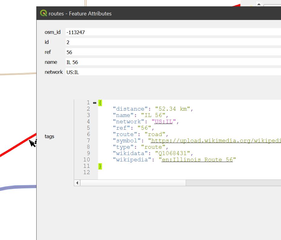
Importing: Road Routes
routes.lua
local ways = osm2pgsql.define_table({
    name = 'routes',
    ids = { type = 'way', id_column = 'osm_id' },
    columns = {
        { column = 'id', sql_type = 'serial', create_only = true },
        { column = 'ref' },
        { column = 'name' },
        { column = 'network' },
        { column = 'tags', type = 'jsonb' },
        { column = 'the_geom', type = 'multilinestring', not_null = true}
    }
})

function osm2pgsql.process_relation(object)
    if object.tags.route == 'road' then
        ways:insert({
            tags = object.tags,
            the_geom = object:as_multilinestring():line_merge(),
            ref = object.tags.ref,
            name = object.tags.name,
            network = object.tags.network
        })
    end
endImporting: Everything
All nodes, ways, and some relations1 are dumped into tables with all their tags.
“Everything” Tables
Why Would I Want This?
- Schema remains as flexible as OSM itself
- As use cases change, only the queries need to be modified, not the data
- No re-importing / re-indexing
- Query output can be used identically to any SQL table using
>>data accessor - Can use queries to populate Materialized Views in postgres
Updating
The Easy Way
Just re-run the import steps whenever a new extract is available from the original source!
For GeoFabrik, this means your data is only a day or so behind the main OSM dataset, depending on:
- When the extract was “cut”
- When you ran your import
The Automatic Way
- Throw all your commands into a script
- Add in a
wgetorcurlcommand to download extract file - Schedule the script to run every 24 hours
Really up to date: imposm
As long as you included -diff in the original import command, updating with imposm simple:
Use imposm run along with the same properties or config file as before.
Really up to date: osm2pgsql
Updating with osm2pgsql needs a replication URL. It works great with the diffs at planet.osm.org.
Issues
- That URL is for global changes
- Replication URLs for Geofabrik exist, but they are daily, not minutely
- Setting up a custom replication URL is not a trivial thing
To limit the changes to your area of interest is possible, but requires some custom coding to work.
If “live” data is needed, probably just use imposm.
Using It
jsonb columns
Using the column ->> 'key' syntax returns the value for the specified key.
Sample Queries
cycling_infrastructure.sql
What to Do
Honestly, once you write the query, you can use the results for anything that you would a normal table, including:
- Publishing a feature service to the web
- Generating vector tiles
- Using as input in geoprocessing
- Create an ArcGIS Locator dataset
- Create a routable graph network
It was noted earlier, but if you’re going to be providing map layers, services, etc., directly from this database, consider writing your query to a Materialized View for a performance boost.
Just don’t forget to refresh them now and then.
Questions?